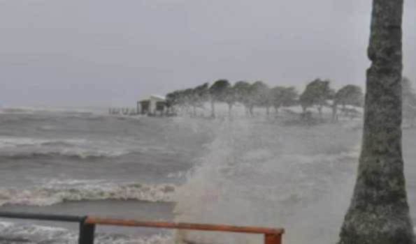


Chennai, Dec 1 (UNI) The remnant of Cyclonic Storm Ditwah, which has weakened into a Deep
Depression, will further weaken into a Depression by noon on Monday, as it closed in on Chennai
coast, even as Met office has forecast heavy rains for the city and its neighbouring districts.
With the system moving closer to Chennai and North Tamil Nadu coast, incessant rains lashed
the city and its adjoining districts since last evening and continued this morning.
In an update early this morning, Met office said the Deep Depression (Remnant of Cyclonic Storm
Ditwah) over southwest Bay of Bengal and adjoining North Tamil Nadu-Puducherry coasts moved
northwards with the speed of 10 kmph during past 6 hours.
It now lay centered over the same region, about 90 km southsoutheast of Chennai, 90 km east-
southeast of Puducherry, 110 km eastnortheast of Cuddalore,180 km north-northeast of Karaikal.
The minimum distance of the centre of the Deep Depression from North Tamil Nadu-Puducherry
coasts is about 50 km.
It is very likely to move nearly northwards parallel to North Tamil Nadu-Puducherry coasts and
weaken gradually further into a Depression by noon of today.
The system will be centered over southwest Bay of Bengal within a minimum distance of 30 km
and it was being monitored by the Doppler Weather Radars (DWRs) at Karaikal and Chennai.
Light to moderate rain is likely to occur at isolated places over Tamilnadu and over Puducherry
and Karaikal area with thunderstorm and lightning at one or two places.
Heavy rain is likely to occur at isolated places over Tiruvallur district adjoining Chennai.
Gale winds with speed reaching 60-70 kmph and gusting up to 80 kmph is likely to prevail over
North Coastal Tamilnadu and Puducherry and Karaikal areas; and squally winds with the speed
reaching 55-65 kmph and gusting up to 75 kmph is likely to prevail over the adjoining districts of
North Coastal Tamilnadu and over the South Coastal Tamilnadu .
Fishermen along and off North Tamil Nadu and Puducherry coasts as asked to refrain from venuturing
into the sea as squally wind with speed reaching 55-65 kmph and gusting up to 75 kmph is prevailing
and it is likely to decrease gradually becoming 45-55 kmph gusting up to 65 kmph lager today.
Sea condition is very likely to be very rough to rough and gradually improve thereafter.
The Met Office advised total suspension of fishing operations in coastal areas of Tamil Nadu, Puducherry
and south Andhra Pradesh coasts for the day and fishermen are advised not to venture into Southwest
Bay of Bengal, Gulf of Mannar, Comorin area and along and off Tamil Nadu, Puducherry and Sri Lanka
coasts.
As the system moved closer, Local Cautionary Signal Number Three (LC-III) was hoisted at Chennai,
Ennore, Kattupally, Puducherry, Cuddalore, Nagapattinam, Karaikal, Pamban and Thoothukudi ports.
Remnant of weakened Cyclonic Storm Ditwah, to further weaken, heavy rains forecast for Chennai